By Chester Butler (University of Florida Master Naturalist)
A biologist, an anthropologist and an insurance marketer enter the forest…sounds like the beginning of a bad joke, right? Not so.

Donna Ingle, the biologist
The biologist is Donna Ingle. Donna was the first female oyster inspector in Florida and currently helps run an aircraft parts business. She dreams of starting an art gallery. Nevertheless, she has not lost her curiosity about all things natural.

John Moran, the anthropologist
The anthropologist is John Moran. John is a doctoral candidate at Stanford University. By interviewing residents, he is documenting the environmental culture in the Florida Panhandle. No small endeavor when you consider the struggle Floridians face in coping with environmental change.

Chester Butler, the insurance marketing executive
The insurance marketing executive, that’s me, Chester Butler. Upon retiring I moved back to my home state of Florida. Things were not as they were 40 years before. Touring my old haunts, I was shocked by the environmental degradation I saw.
John and Donna were way ahead of me on the reasons why Florida has so many environmental challenges. They had lived part of the change. All three of us enrolled in the University of Florida Master Naturalist Program, eager to learn more about the changes in the environment we saw every day and how to live with them.
The Master Naturalist Program is designed to bring awareness and understanding to those of us who want to understand the dramatic environmental challenges we face. The program also trains candidates to be focused observers in three different environments: freshwater wetlands eco-systems, coastal eco-systems and upland eco-systems.
Our instructors, Rosalyn Kilcollins and William Sheftall, are dedicated, knowledgeable and experienced naturalists. They were patient as they challenged us to study, observe, and then draw our own conclusions. Then pointed out to us other possible explanations and conclusions. They provided “On the Job” training for budding naturalists. In fact, every student must participate in three hands-on projects before a designation is awarded.
In the late spring of 2016, Rosalyn suggested that John, Donna, and I might want to contact the Florida State University Marine Laboratory about using their property for our Uplands project. The Lab was to be expanded in the near future, and on a hillside adjacent to that proposed site, there were Long Leaf pines they wanted to preserve. We jumped at the chance.
The FSU Lab agreed to allow us to work on their property and asked Christopher Matechik, a Lab assistant, to orientate us. Chris was already at work on the hillside of about 70 acres that we were to use as our study area. He and volunteers had mechanically and manually removed years of undergrowth and duff on the lower hillside; no small endeavor. The site was due for its first prescribed burn in the fall of 2016.
We asked Chris what kind of work had been done on the site in the past. He said there was little to tell. Loran B. Anderson, PhD., the well-known Florida State University botanist, had completed a plant survey. There had been some dumping of dredged material on the site at some point in the recent past. Chris supplied us with maps of the property and Dr. Anderson’s plant survey.
A few days later, Chris and I were on the property clearing duff from around the base of Long Leaf and Slash Pines, prepping for the burn. Too much fuel around the roots and the rootlets burn. That could kill a tree. Natural fire moves quickly through the landscape, so the regenerative aspects of fire are delivered to the forest and the heavy destruction is avoided. That is if the forest is burned regularly and in the proper season. The application of restorative fire is unique to pine forests. Foresters said that even with the removal of the duff and woody understory, this hillside was too dry to burn. They would wait until fall to burn.
“So have you and your partners come up with a project?,” Chris asked.
“No, we’ve talked about a lot of things but no agreement yet,” I replied. I went on, “Donna is focused on the Long Leaf restoration. John has spotted a cat-faced tree. So he is wondering what went on with this patch of land over the years. Me, well, I am thinking maybe we could do a habitant study. Frankly, we are a bit stuck.”
“Why don’t you just come up with a hypothesis and then test it, to see if it’s right or wrong?” Chris asked.
Chris is well schooled in the scientific method and he was giving me more credit than I deserved. Luckily, my partners were more familiar with this type of investigative procedure.
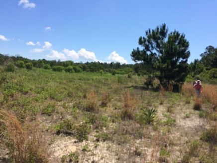
Nevertheless, Donna, John and I did observe something that was to set the stage for our investigation of the site. The Slash and Long Leaf Pines were interspersed on the lower 40 acres of hillside. Higher up the hill, there was a band of Titi and then a grassland-like area. We had noted this from aerial photos but did not realize what significance it might have for the pines.
 We also noticed that some of the Long Leaf Pines had developed flattened tops. This usually indicates that a tree had reached its mature size. Long Leaf Pines can live 400 years. But these trees did not appear to be that old. The Slash Pines did not show this characteristic. Why not, we wondered?
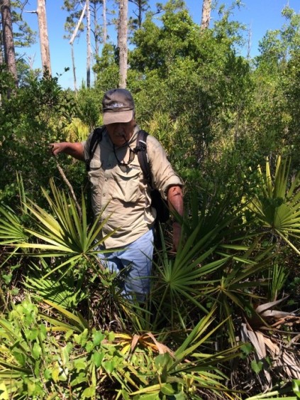
On the day we made these observations, we spotted a Sharp Shinned Hawk and we’d see this bird again on our visits. He was taking advantage of the prey available now that the thick layer of duff, palmetto and other woody shrubs had been removed. Our conversation, and our stumbling as we stared up at the pine canopy, ruined his breakfast foray and he moved on.
We observed other wildlife on our initial visit, a few skinks rattled the patches of shredded palmetto debris. Song birds flitted from tree to tree. And we found a few signs of the nocturnal activities of small mammals such as opossums and raccoons in some small patches of wire grass. This triggered a discussion of the possibility of the reintroduction of the key species characteristic of Long Leaf Pine forests. We quickly eliminated this idea because all these species needed home ranges larger than the site.
We left the site that day with an intriguing question, why did the Long Leaf Pine’s growth appear to be arrested?
We needed more information. We decided to take soil samples. Maybe there was a difference in the soil that caused the arrested growth? We would core drill some of the pines to determine their age, too. Perhaps, some event occurred to stunt the Long Leaf trees. But why were the Slash Pines not affected?
 We found one cat faced tree on the site. John and Donna would investigate the local history and the history of timbering in the area to see if there might be some historic correlations that might be helpful to our investigation. Maybe a hurricane or killing fire (one that burns hot and long) somehow figured into the answer.
We also wanted to check out the area we were told was used to dump fill from dredging. Did it affect the pines down hillside?
Our Investigation
We did soil core drillings on the lower hillside, running transects east and west and north to south. We cataloged the elevation, latitude and longitude of each core sample. We drilled down until we hit water-saturated soil. We hit water-saturated soil at very shallow depths, coming very near the surface as we moved downhill. This surprised us because there are two drainage streams on both sides of the site well below our drill sites. On the lower core drillings, we were hitting water and anaerobic decay at about three feet. This indicated the organic material was submerged for long periods. The depth of water-saturated soil remained constant along our east and west transects.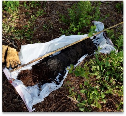
Using a soil kit, we classified the types of soil from the color and size of the granules. We cross referenced the soils types with the most recent Franklin County Soil Survey (1994). We identified five soil types. None were suitable for building without modifications such as compaction. Most tended to flood easily.
We dyed the tree core samples to make counting the annual growth rings easier. The core drilling of several larger trees told us the trees were from 90 to 110 years old. Will Sheftall went beyond the call of duty and assisted us with the tree coring and hiked the top of the hill with us on a very hot and humid day. We were grateful for his cheerful input even though the going was tough.
We saw several Pond Pines near the top of the hillside, some in good health. The nearby snags, based on their size, were likely Pond Pines, too. These pines were along the edge of the fill area. The fill area was mostly grasses, woody plants and a few small hardwood trees. We did not core drill the earth in the fill area. It had been core drilled by others and we did not have access to that information.
John found that Dr. Anderson’s 2009 plant inventory was cataloged into the Florida State University Herbarium website (www.Herbarium.bio.fsu.edu) . The Herbarium’s database preserves Dr. Anderson’s work. However the data was not recorded in FSU Marine Lab database so John input all 123 species for quick and easy access in the lab. The plant inventory confirmed what we saw in our explorations. The plants were the type you would expect to see in flatwoods and pine scrub. It also included water loving plants, but it did not address the Pond Pines we saw.
Our Conclusions
 The Pond Pines, and the soil samples indicate the hillside contains and holds more water than the casual observer might expect. It is likely that in the past there was a “bowl” of freshwater on the hill top. This allowed Pond Pines to thrive around it because they like “wet feet”. It also made it an attractive place to place dredge fill. The placement of fill could have the effect of causing the bowl to overflow with any rain sending water downhill. Or the water flow could be the result of the cap trapping water. The cap would prevent surface evaporation and there is little vegetation to hold it on the surface. This allows more water to seep into the larger granular soil strata below. Even ephemeral ponds on the hill top might provide enough evaporation to be an effective mechanism to lower the water table on the hillside.
Our soil core samples did show a layer of large granular soil indicative of an ancient dune which could act as a lateral water pipeline across the hillside. Our samples and the 1994 County Soil survey indicated soil types that are sandy, infertile and usually have a history of high water tables.
Whatever the structure or reason for the soil saturation, it is not healthy for the Long Leaf Pine. These pines need water but are prefer much drier soil than the water loving Pond Pines or the water tolerant Slash Pines. It is the adaptation of the Slash Pine to tolerate as much as 90 days of “wet feet” annually. This is one of the reasons it is the most popular cultivated pine.
So, it may be that the Long Leaf Pines on the site are adapting to the wet soil by “topping out”. Their growth is limited by too much water content in the soil.
We knew that the Long Leaf needs both fire and an open canopy to germinate. The open canopy is needed because the Long Leaf has a “brush stage” that can last several years. That had to be taken into account when aging the trees. So we added the appropriate years to the Long Leaf core samples to determine a tree’s age. When we compared the core samples from the Long Leaf Pines to the core samples from the Slash Pines, they confirmed what Donna had theorized early on, the Long Leaf Pines were older than the Slash Pines. The oldest Long Leaf was about 109 years old and the oldest Slash about 83 years old.
John took a look at cultural factors. He composed a timeline of activity from 1894 through 1966. The cat faced tree on the site was evidence of turpentining activity. It set a cultural time backstop because it was not invented until 1902.
We surmised that the area was timbered after the turn of the century. This left an open canopy with time for the Long Leaf to germinate. Sometime after that, maybe in the 1930’s or later the Slash Pines germinated. As these trees matured, they were used to harvest sap for turpentine. We found no evidence of timbering in the fill area. It was likely some type of forest wetland.
On the west side of Franklin County, the limestone base can be 400 feet deep. But it reaches to as little as 12 below the overburden, as it reaches the Ochlockonee Inlet. So, a spring close to the site cannot be ruled out as a contributor to the water table on the hillside. However, we found no evidence of one.
Another theory we kicked about is that the hurricane of 1900 toppled the Long Leaf on the hillside. We dismissed this idea because there was no evidence of snags (standing or on the ground)) except smaller ones on the west side of the hill.
Our findings are not conclusive and much more study would be needed to confirm with certainty the ecological and cultural history of this little hillside. One thing seems certain, at the moment, the hillside is a better environment for the Slash Pine than the Long Leaf Pine.
Based on what we found, what is the best use of this property? The soil types on the site are not suitable for building. However, Florida State University Marine Laboratory plans to build a new facility just west of this hillside, where the soil is suitable. The future of the private land to the north and east are unknown. It is our opinion that this 70 or so acres can complement the FSU Marine Lab building program aesthetically and provide demonstration area for indigenous coastal species.
Many universities have developed such areas on or adjacent to their campuses. And this area has much going for it as an educational resource. Here are just a few ideas:
- We found four transitional zones or edges which provide good habitant for different types of plant and animal species. These edges provide opportunities for wildlife viewing.
- There are drainage creeks on both sides. A perfect home for freshwater species of plants and animals.
- The drainages empty in to the Gulf which provides another unique transition area. Currently at least one alligator has found a home in this little coastal water shed.
- The hillside can become a resource for the Panhandle and Gulf Coastal plains students and educators and be used for education and dissemination of information about restoring native habitant. The University of North Carolina at Chapel Hill has developed a botanical garden in a natural habitat. (http://ncbg.unc.edu/) similar to what could be developed on this site.
- FSU could partner with St. Marks National Wildlife Refuge to enhance the Monarch Recovery Program by using the coastal acreage located in the flyway of the Monarch migration.
- It can be a place to preserve the reminders of the cultural and historic use of the site, such as the cat-faced tree we found for interpretive purposes.
- Because it is located on the Marine Lab property it could also be used to present the history of the mullet seine yard history of the Wakulla and Franklin Counties.
- It can be used to showcase the coastal transition areas from the harbor up the hillside.
- Develop a trail system to provide access to the various habitants and future maintenance of the property.
After our study, John returned to Stamford to complete his doctoral studies. Donna has returned to her business endeavors and her dream of establishing an art gallery in Apalachicola. And me? Well, I am the lucky one. I continue my retirement. I spend my days chasing speckled trout and redfish on the turtle grass beds that surrounding the FSU Lab. And some mornings, as a sea breeze pushes my skiff across the Lab’s channel, I stare up at the little hillside, wondering what the future holds for it and the gator that calls the Lab’s harbor home.
Special thanks to all those students and faculty at the FSU Laboratory that made Donna, John and I feel at home when we visited, asked questions or needed to use the shop. We have attended special programs at the Lab and are happy to have such a great resource located in Franklin County.


 arch Award.
 on board the research boat and surgically implanting the shark with an acoustic tracker. The shark is then released and the fun begins.

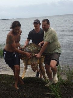
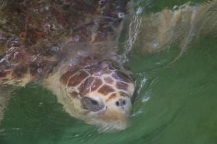
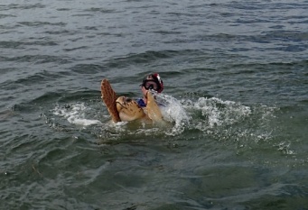
 They arrived a short while later and used a sort of ‘sea turtle swaddling cloth’ to properly support her while she was loaded up for treatment at the institute.